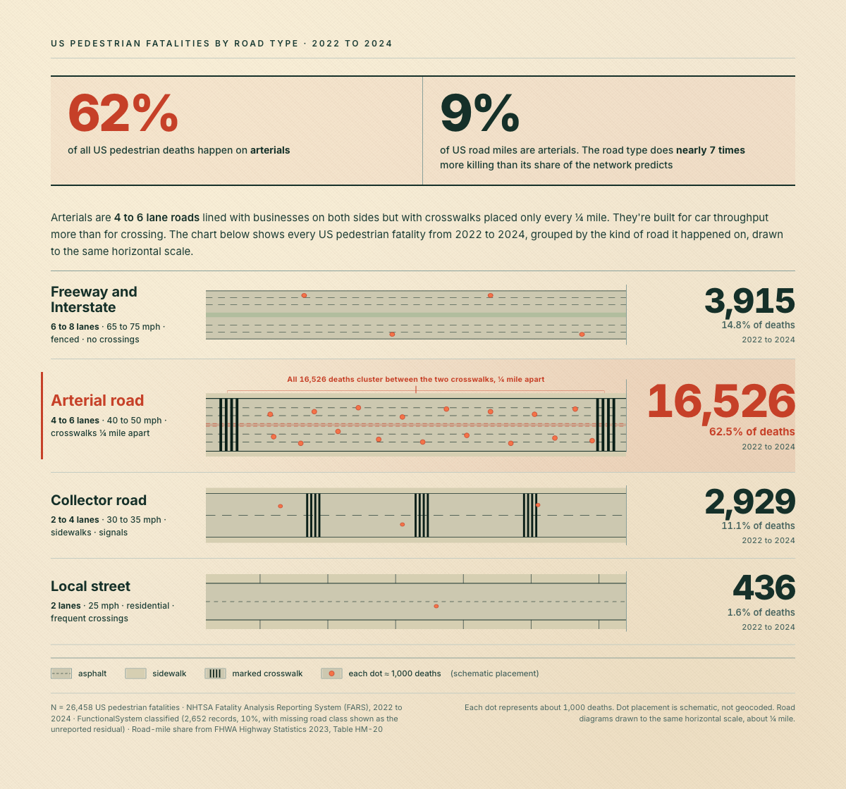
**Death counts:** NHTSA Fatality Analysis Reporting System (FARS), 2022 to 2024. Filtered for pedestrian fatalities (PER_TYP=5 in PERSON.csv). N = 26,458.
**Road type:** FunctionalSystem field on the matching ACCIDENT.csv record. About 10% of crashes (2,652 records) had no road class assigned. I left those out of the chart instead of redistributing them, which is why the four bars sum to 90% not 100%.
**”Arterial”:** combines two FHWA categories, Principal Arterial (Other) and Minor Arterial. Interstates are the row above.
**Tools:** HTML and SVG
**A note on the schematic:** each red dot represents about 1,000 deaths. Dot placement is illustrative, not geocoded. The cluster between crosswalks reflects the dominant FARS pattern: mid-block, far from a marked crossing.
I love everything about this info graphic. Top tier, OP!
EDIT: username checks out, too
avatoin on
These are the worst kinds of roads. Designed entirely around cars with pedestrian traffic at best an afterthought, if they are considered at all. Cars drive way too fast, and it forces pedestrians to travel far to travel short distances. A store can be right across the street, but you’d have to walk a mile in order to navigate the few crosswalks that actually exist, plus the large parking lots.
It was a mistake to allow business to be built, front facing the road, like they are. They should be borderline exclusive to cars, with businesses and residential being off to the side, creating mini communities of business and residential. Once your inside the community, you are physically separated from the faster cars and have little reason to interact with them. Then the paths to cross communities are built with sufficient physical barrier or separation to create a safe walking path.
OldSports-- on
Very interesting finding.
And a perfect example where small efforts can have a big impact.
OnboardG1 on
50mph arterial roads in the UK almost never have pedestrian access because of this. They have paths running beside or below them. There have been a few exceptions in the past I can think of in my council area. They were legacy 40mph roads that had facilities along them, but they’ve all been cut back to 30mph limits where people often cross them because of how dangerous they were.
symphwind on
Great visualization, depressing data. I know the arterial roads/stroads are the focal point but 4000 pedestrian deaths on interstate highways is wild to me, when pedestrians aren’t allowed on them at all. Do people stopped in the shoulder count as pedestrians?
Nomad624 on
I love how road design in America sucks for literally every form of transportation. Between the inefficient and dumb (stopping at a red light with no other traffic to be seen is a common part of life here) signalized intersections, to the subsequent widening of the intersection making crossing them on foot impossible, it’s a complete disaster in every part of the country.

8 Comments
**Sources & methodology**
**Death counts:** NHTSA Fatality Analysis Reporting System (FARS), 2022 to 2024. Filtered for pedestrian fatalities (PER_TYP=5 in PERSON.csv). N = 26,458.
**Road type:** FunctionalSystem field on the matching ACCIDENT.csv record. About 10% of crashes (2,652 records) had no road class assigned. I left those out of the chart instead of redistributing them, which is why the four bars sum to 90% not 100%.
**Road-mile share:** FHWA Highway Statistics 2023, Table HM-20.
**”Arterial”:** combines two FHWA categories, Principal Arterial (Other) and Minor Arterial. Interstates are the row above.
**Tools:** HTML and SVG
**A note on the schematic:** each red dot represents about 1,000 deaths. Dot placement is illustrative, not geocoded. The cluster between crosswalks reflects the dominant FARS pattern: mid-block, far from a marked crossing.
Full piece with the additional breakdowns (lighting, speed, income, what fixes it) is here: [https://safestreets.streetsandcommons.com/insights/pedestrian-deaths](https://safestreets.streetsandcommons.com/insights/pedestrian-deaths)
Looks like the Pareto Principle strikes again! 🙂
I love everything about this info graphic. Top tier, OP!
EDIT: username checks out, too
These are the worst kinds of roads. Designed entirely around cars with pedestrian traffic at best an afterthought, if they are considered at all. Cars drive way too fast, and it forces pedestrians to travel far to travel short distances. A store can be right across the street, but you’d have to walk a mile in order to navigate the few crosswalks that actually exist, plus the large parking lots.
It was a mistake to allow business to be built, front facing the road, like they are. They should be borderline exclusive to cars, with businesses and residential being off to the side, creating mini communities of business and residential. Once your inside the community, you are physically separated from the faster cars and have little reason to interact with them. Then the paths to cross communities are built with sufficient physical barrier or separation to create a safe walking path.
Very interesting finding.
And a perfect example where small efforts can have a big impact.
50mph arterial roads in the UK almost never have pedestrian access because of this. They have paths running beside or below them. There have been a few exceptions in the past I can think of in my council area. They were legacy 40mph roads that had facilities along them, but they’ve all been cut back to 30mph limits where people often cross them because of how dangerous they were.
Great visualization, depressing data. I know the arterial roads/stroads are the focal point but 4000 pedestrian deaths on interstate highways is wild to me, when pedestrians aren’t allowed on them at all. Do people stopped in the shoulder count as pedestrians?
I love how road design in America sucks for literally every form of transportation. Between the inefficient and dumb (stopping at a red light with no other traffic to be seen is a common part of life here) signalized intersections, to the subsequent widening of the intersection making crossing them on foot impossible, it’s a complete disaster in every part of the country.