
Given current global affairs, I decided it would be fun to calculate a Least Cost Path that bypasses the Strait of Hormuz while I teach myself QGIS. In GIS, a least-cost path assigns a 'cost' to each pixel in a raster and computes the path with the lowest cost using a pathfinding algorithm such as Dijkstra's.
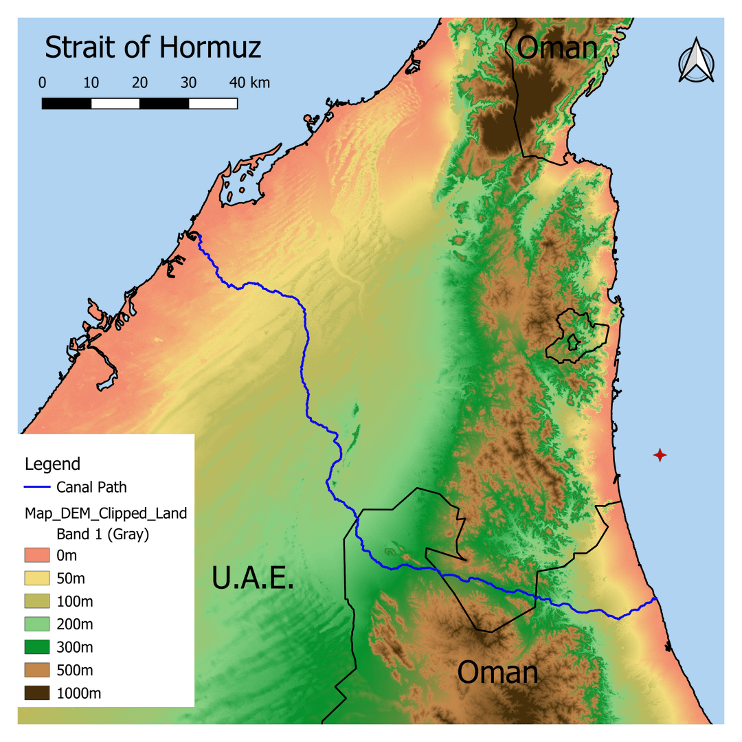
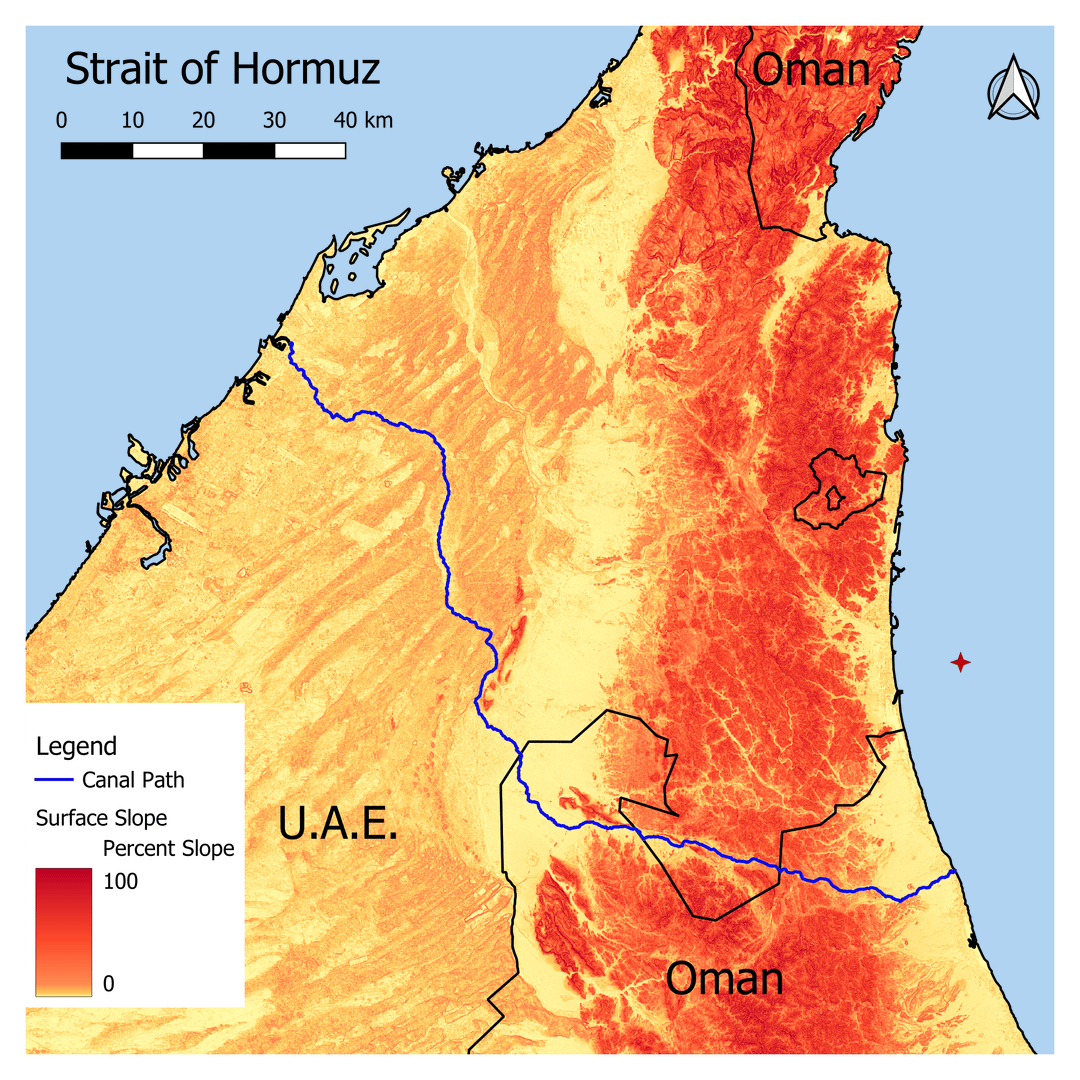
From a 30m resolution Digital Terrain Model (image 2), slope (image 3) was calculated. From the slope, an Elevation Cost Multiplier raster was calculated by splitting the slope into 3 intervals: less than 3 percent, less than 10 %, and greater than 10 %.
These intervals were selected based on a New Pananamax lock length of 450m and a 10m elevation gain per lock (New Pananamax is 8.66m elevation gain per lock. Slopes of up to 10 percent could be tolerated over short distances but should be avoided. Slopes of greater than 10% are essentially impassable for a large ship canal and are heavily penalized.
**Formula IF elev <3 than (elev^2)/9 IF elev <10 than elev*2, else 100.
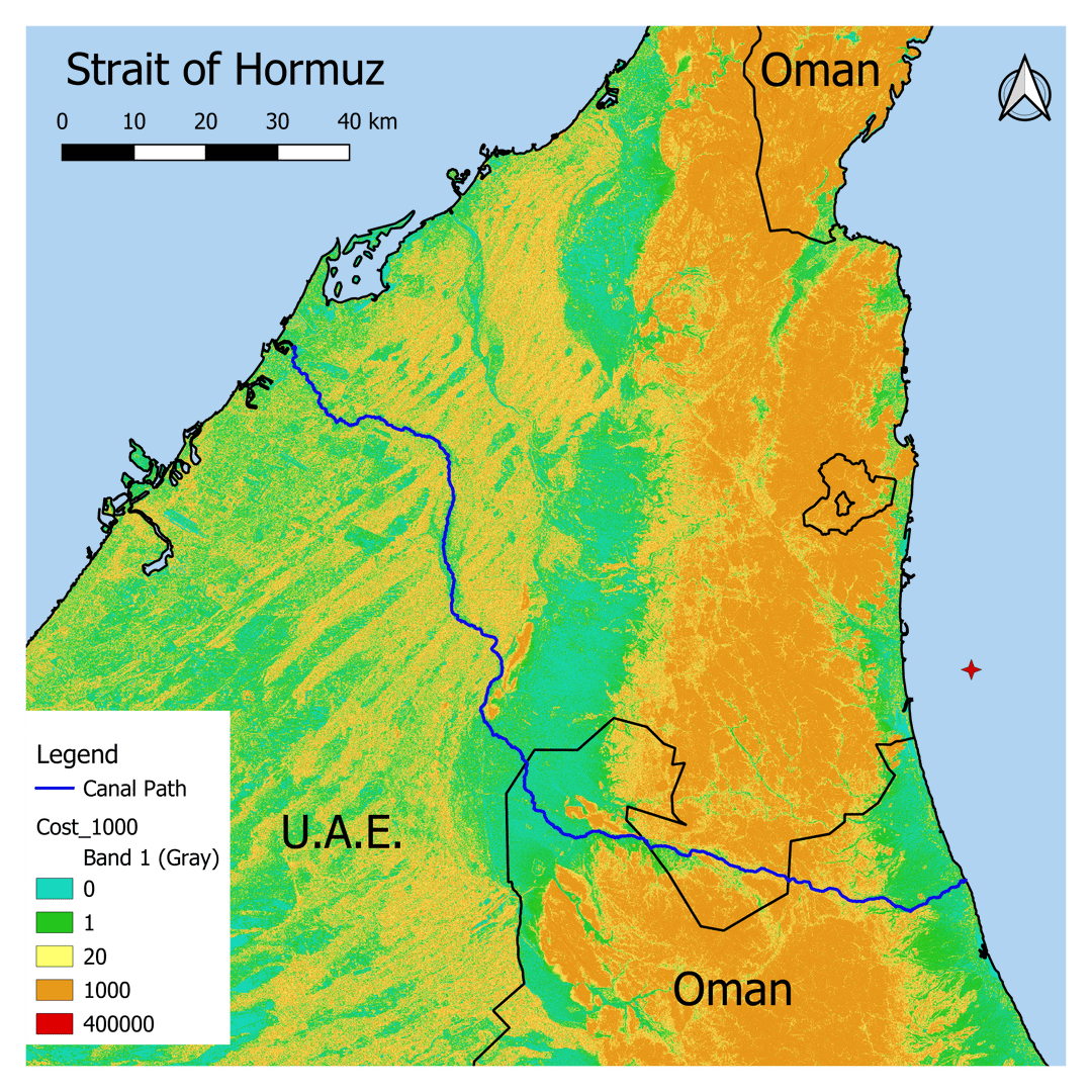
The Elevation raster is then multiplied by the Elevation Cost Multiplier raster to give the Cost Raster (image 4)
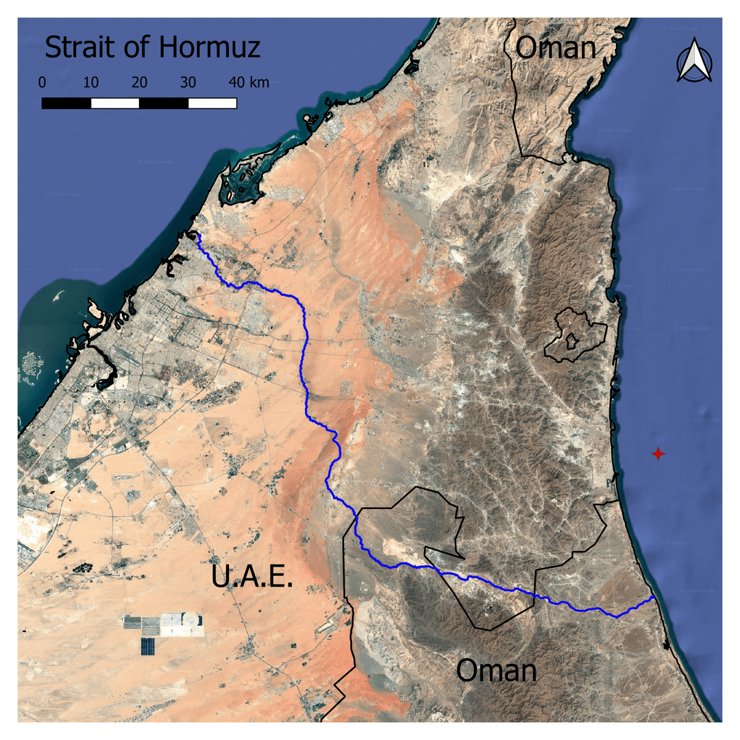
The Cost Raster is then used in the Least Cost Path tool in QGIS. The Start point is just west of the western screen edge between the Palm Islands, and the End point for the calculation is the red star near the eastern coast. Water was given a 0 cost, so the accumulated cost from the start and end point to any point on the coast is 0.
Does this path make sense?
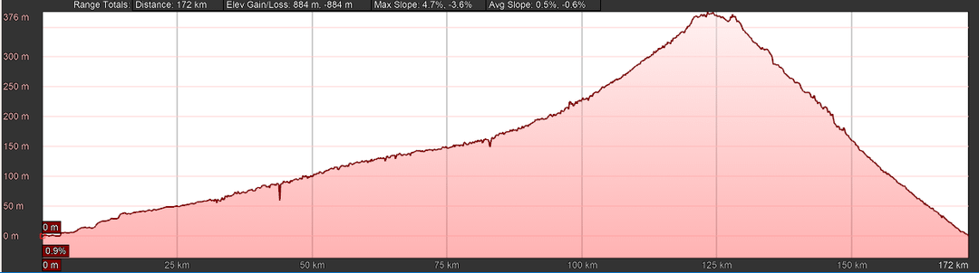
The elevation profile at the end is the path dumped into Google. Earth Pro. It gives an average slope of 0.5% and a max slope of 4.5%. This is approximately 175km; some minor straightening reduces it to ~150km. These are both technically fine for a large canal. I do not think the 36 Locks required to ascend and 36 more to descend are reasonable for a real canal, but I am not a marine/civil/mega project Engineer.
When I started, I thought it would yield a result somewhere between ridiculous and ludicrous. As I looked at the results and and costs from the Suez and Panama expansions it started to seem a bit less rediculous. Panama spent about 500 million per lock, and Suez was about 8 billion for 35km of canal. Applying those numbers here, we have 150km x 2 for canal X 8/35 = 68.57 Billion for canal construction and 36 Billion for locks. An Economical 105 billion, probably less than the global Economy has lost in the last 2 months.
Data:
ESA global elevation model – Copernicus DEM GLO 30.
Political Boundaries – GeoBoundries.org
Tools:
QGIS
Google Earth Pro
TL;DR : Concept of a plan for a canal by-passing the Strait of Hormuz. derived from elevation and slope datas. (and rainbows)
by JohnathantheCat
33 Comments
It’s still well within striking distance for Iran.
If only there was some sort of natural body of water nearby that traversed the same path…
It’s not like they can’t shoot a little further.
You forget the cost for bridges and maintenance cost. A pipeline would make more sense.
376m? That’s just madness, you’d need so many elevators. It will simply take an eternity.
A tunnel would make more sense than a 370m+ lock system for a canal
With thesize of the oiltankers, isn’t that an awful amount of steering?
Least cost is not to start a war without a plan.
You also have to bear in mind that the canal will have to take tankers which are loaded with oil.
I say that as I worked on VLCCs carrying 300,000 tons of crude and if we were loaded, we couldn’t go through the Suez canal and had to round the Cape of Good Hope instead if we were heading for Europe or the US.
This was back in 2003 though and I’m not sure if this has changed.
Edit: typo and another typo.
Somebody will just build a better drone, sink/immobilize a ship or two and block the canal.
One needs tons of extra water storage to operate a canal. It’s hard to describe in words but when water is pumped into and out of canal levels, that water has to come from/be stored somewhere. Which would be an additional logistic challenge.
Also, as others have pointed out, the canal both during operation and construction would be an easy and static target for Iran.
Why though? It’s not going to stop Iran from attacking ships. Ships would still be within range of Iranian missiles, fast attack boats, and drones when approaching the canal and the canal infrastructure itself is very vulnerable.
This is interesting, though pipelines are a much more feasible solution, hopefully this crisis is actually the spark that gets Iraq, the UAE, and Saudi Arabia to build more capacity.
A few pipelines would be alot easier
I think oil pipelines to Arabian Sea + a giant new port in Oman is still gonna be 10 times cheaper than this.
Saudi is already diverting a lot of their oil via pipelines to export via Red Sea.
It’d be much cheaper if you built it here:
https://preview.redd.it/8vh1d9lbqsxg1.png?width=1438&format=png&auto=webp&s=92e2f89da1baff3acb540d79d9882e98226e01d8
An estimated cost, without knowing the geography of the area, is just a guess with no real base in reality.
How easy is it to even construct just the infrastructure to build a canal that big in that area?
And of course *~~ever~~* *given* that a canal is an easy target to disrupt, it still wouldn’t solve anything,
Very interesting process though exercice ! well done !
Do you have any rain data to mix in ?
It doesnt seems that this area is getting a lot of rain water to fill up the locks. That means pumping back everthing every time…. we could calculate how many m² of solar panel we need to pump everything back up 🙂
Im surprised that the route from Ras-Al-Khaimah south (west of the Oman border), then following the path of the E87 road through Dahir and entering the sea around Dibba-Al-Fujairah isn’t cheaper. Something like this: https://maps.app.goo.gl/TMh5hUhUmTpyYykFA
It looks like the mountainous bit is similarly graded but shorter, and the Western half is also similarly graded but shorter.
OP are you able to simulate that route to work out how much more it would be?
Ahem.
And you’re still in missile range of Iran.
Have fun with that.
Is that an enclave within an enclave?
Doesn’t UAE already have (or will soon have) Boring Company tunneling equipment in country for the Dubai Loop? Theoretically, they can tunnel up to one mile per week. Seems like the most practical approach if there are serious plans to bypass the strait.
Nice work, and a fun thought exercise / practical training. Functionally it’s still crazy, in that it doesn’t really solve the region’s problems, but you did a really nice job of coming up with a decently thought out proposal and accointing for a lot of relevant externalities in the solution. It’s pretty too. Well done.
Iran has already shown willingness to blow up
oil infrastructure in neutral countries to contribute to the oil shock. A canal is arguably even more static of a target then an oil refinery (at least a refinery could be rebuilt somewhere else or some critical equipment could be uninstalled and sheltered somewhere). If we can’t protect US military bases in the region from getting hit, I’m not sure how we could keep the hundreds of locks and pumps needed to keep this thing running safe from missile and drone attacks.
Also, the tankers would be sitting ducks in the locks. I’m sure it’s hard to hit one with a missile, but the threat of hitting one could still keep insurance rates prohibitively high I would imagine.
I don’t think building a narrower canal in the same vicinity would do a lot to overcome this blockade. The vulnerable points of the canal would be the first strike in any escalation, forcing traffic back to the straight.
Maybe if Trump just resigned, we could go back to having normal (strained but stable) relations with Iran, and someone with actual negotiating skills could continue developing a treaty to prevent nuclear proliferation. Just a crazy thought. That maybe the problem isn’t shipping lanes, but having an ignorant maniac involved
Or, you know, invest in other sources of energy
This could be bombed and shut down by Iran. So what’s the point.
Like drones would make this impossible
Operation Plowshares, my beautiful…
While this is one of the stupider ideas that everyone on the Internet won’t shut up about, I really like how OP went about doing the analysis. Clever use of GIS data, automated pathfinding, good consideration of canal design criteria, and effective graphics.
Sometimes we do things not because they’re good ideas, but because they’re fun, and OP has done a great job.
You can also flip this around, and use OP’s analysis to show how dumb the Omani canal is. Even chosing a computer-optimized route through the mountains, you still end up with a canal that’s as long as the Suez, requiring an elevation change 10 times higher than the Panama Canal.
Why is this idea so persistent? Does everyone think this situation is going to be a permanent feature? If Iran truly has a permanent hold on the strait, everyone would just pivot away from gulf oil by the time a canal was operational.
They should make airships into lng carriers
And what now OP? That’s it? Build that thing! The Great Johnathan The Cat Canal
Does this account for the volume the Strait handles vs. the volume a canal can handle?