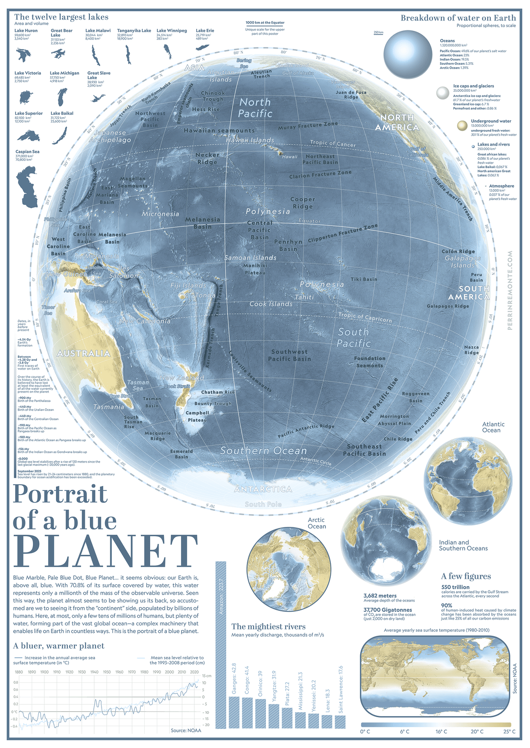
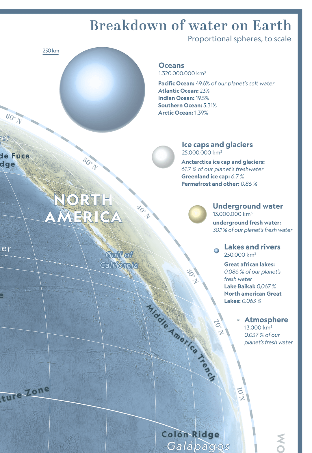
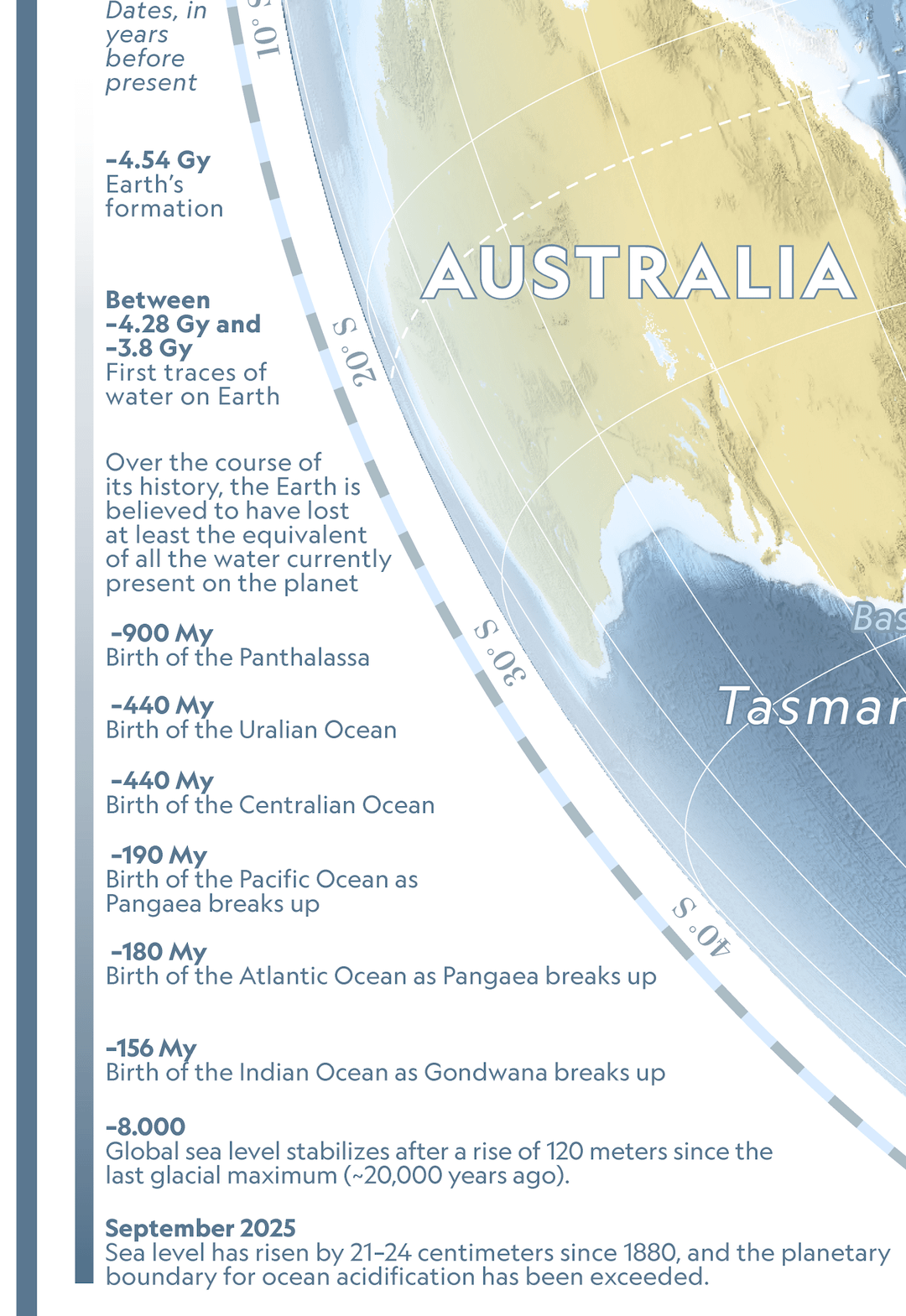
“Blue Marble, Pale Blue Dot, Blue Planet… it seems obvious: our Earth is, above all, blue. With 70.8% of its surface covered by water, this water represents only a millionth of the mass of the observable universe. Seen this way, the planet almost seems to be showing us its back, so accustomed are we to seeing it from the “continent” side, populated by billions of humans. Here, at most, only a few tens of millions of humans, but plenty of water, forming part of the vast global ocean—a complex machinery that enables life on Earth in countless ways. This is the portrait of a blue planet.”
Kind of strange seeing something great here and not some slobbered together trash with weird colors or just a link to shitty website.
Nice.
PM_ME_UR_EYEBALL on
This reminds me of those eyewitness books I used to love as a kid. Great work
bitingmyownteeth on
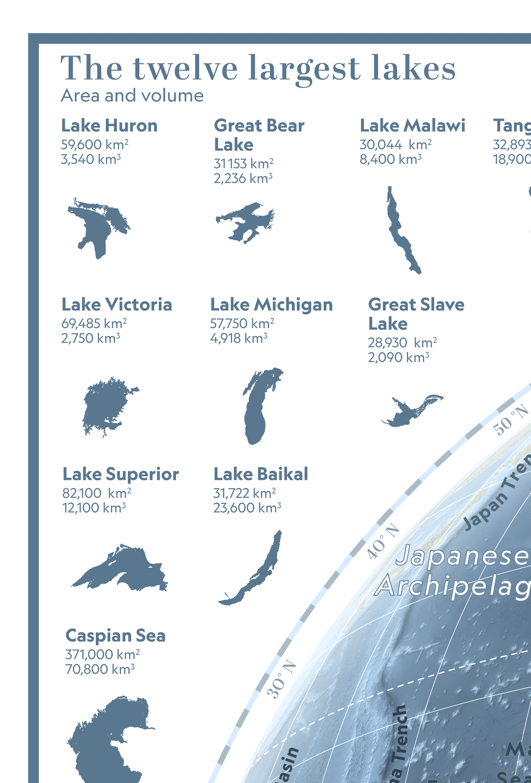
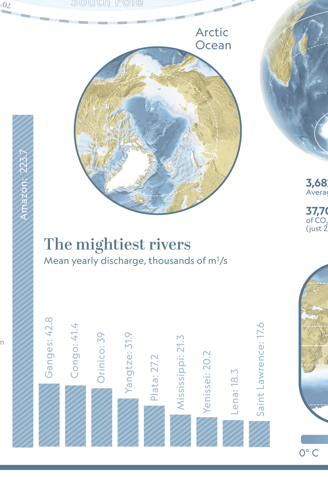
I never knew the Amazon was THAT MUCH BIGGER
MyPenisSpeaksChinese on
Lovely work! Just one thing, it’s the *Orinoco* River, not ‘Orinico’.
Edit: pretty sure there’s also only one S in Yenisei.
Zypherdose on
Amazing infographic! Its like a poster you would see in a school hung up.
Betray-Julia on
I don’t know what they are called, but these remind me a lot of those info books on space and oceans and machines and buildings and geography from my childhood circa 90s.
yooperville on
Beautiful! I live near Lake Superior
savargaz on
Amazing! Can you describe your general workflow for making a map like this? What software/tools did you use etc? I’d like to learn 😁

11 Comments
“Blue Marble, Pale Blue Dot, Blue Planet… it seems obvious: our Earth is, above all, blue. With 70.8% of its surface covered by water, this water represents only a millionth of the mass of the observable universe. Seen this way, the planet almost seems to be showing us its back, so accustomed are we to seeing it from the “continent” side, populated by billions of humans. Here, at most, only a few tens of millions of humans, but plenty of water, forming part of the vast global ocean—a complex machinery that enables life on Earth in countless ways. This is the portrait of a blue planet.”
More maps on my [website](https://www.perrinremonte.com/fraccueil-1)! (not smarphone friendly)
Data: GEBCO, NOAA
Tools: QGIS, Adobe Illustrator
Absolutely gorgeous!! Great work as always!
Amazing work! Have you considered doing Youtube videos on how to make something like that?
This one is also amazing piece of work from your website: [https://www.perrinremonte.com/thema-eng?itemId=qzdobsofhd3nmw0k483ptdmiv1se5l](https://www.perrinremonte.com/thema-eng?itemId=qzdobsofhd3nmw0k483ptdmiv1se5l)
Kind of strange seeing something great here and not some slobbered together trash with weird colors or just a link to shitty website.
Nice.
This reminds me of those eyewitness books I used to love as a kid. Great work
I never knew the Amazon was THAT MUCH BIGGER
Lovely work! Just one thing, it’s the *Orinoco* River, not ‘Orinico’.
Edit: pretty sure there’s also only one S in Yenisei.
Amazing infographic! Its like a poster you would see in a school hung up.
I don’t know what they are called, but these remind me a lot of those info books on space and oceans and machines and buildings and geography from my childhood circa 90s.
Beautiful! I live near Lake Superior
Amazing! Can you describe your general workflow for making a map like this? What software/tools did you use etc? I’d like to learn 😁