
Good day to you all, my name is Joseph, a want to be data analyst, here to share a discovery I made while scraping Google Map for my job hunt.
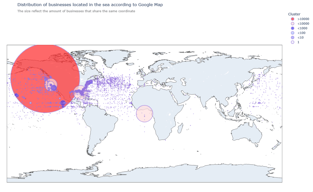
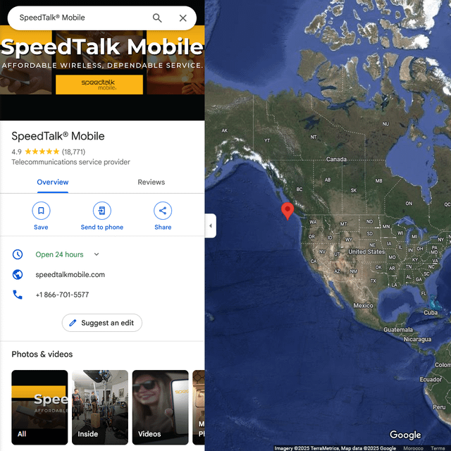
When I was doing EDA on data I collected, I noticed that some businesses are not on land; after further investigations, it turns out that almost 3% of businesses are on the sea; after analyzing those 3%, I found out that 73% of them share the same geo-coordinate, i.e. [46.423669, -129.9427086].
This discovery made me wonder, is that the coordinate that Google default to when an invalid input is given?
Were the other randomly scattered businesses on the sea intentionally put there?
I tried to contact a few journalists to help in the uncovering of this mystery… but no one showed any interest; if you want, you can share it, as long as a tiny attribution is made.
Here are some resources:
– Data I scraped and used to generate the plot, both in CSV and Parquet:
https://drive.google.com/drive/folders/1rCXC7h1kgVbcUA0Bu5yXj4NGUbqst2Cl?usp=sharing
– Tools I used:
Selenium Base, Pandas/Polars, Plotly Express, Jupyter Lab.
– Interactive plot:
https://josephelhaddad.github.io/plotly/b_in_sea2
– Blog post I made on my ugly website:
https://josephelhaddad.github.io/20250109T202901–google-map-plan__note.html
You can DM or leave a comment if you wish to investigate this together, ask me a question, give me and advice, or to tell me how unpleasing is my website.
PS: This is my first post, but it might also be my last… please be gentle to this data Hobbit.
PPS: I hope I didn't violate any rules.
by JosephErgo
6 Comments
I’ve come across this anomaly a couple of times trying to look up some local businesses, or even previously saved locations, only for Google Maps to whip around to a seemingly random location off the coast of BC. Your analysis provides an explanation for something that’s been bugging me for a while!
Are any of the locations Krusty Krab restaurants? 🧽
that’s less businesses on [null island](https://en.wikipedia.org/wiki/Null_Island) than I expected
this is actually a great find, man. that cluster around 46, -129 totally screams “null island but off by a few degrees.” google (and a bunch of other systems) often dump bad or missing coords to some default point if the data pipeline can’t resolve the address. could be a fallback in their geocoder or even a quirk in whatever dataset they’re syncing from.
The ones that don’t seem defaulted, do they resolve to any land locations if the signs (+/-, ns, ew) are inverted?
There’s quite a few that seem to sit along the same few latitude lines, see the grid style appearance in the Caribbean and continuing into the Pacific. No doubt just using integers for their lat/long, on top of the original error.
Can any of these resolve to zip codes that make sense?