**Data source:** OpenStreetMap (amenity=toilets nodes), queried April 2026. Licensed under ODbL.
**Tools:** PostGIS for spatial queries within municipal boundaries, HTML/CSS for visualization.
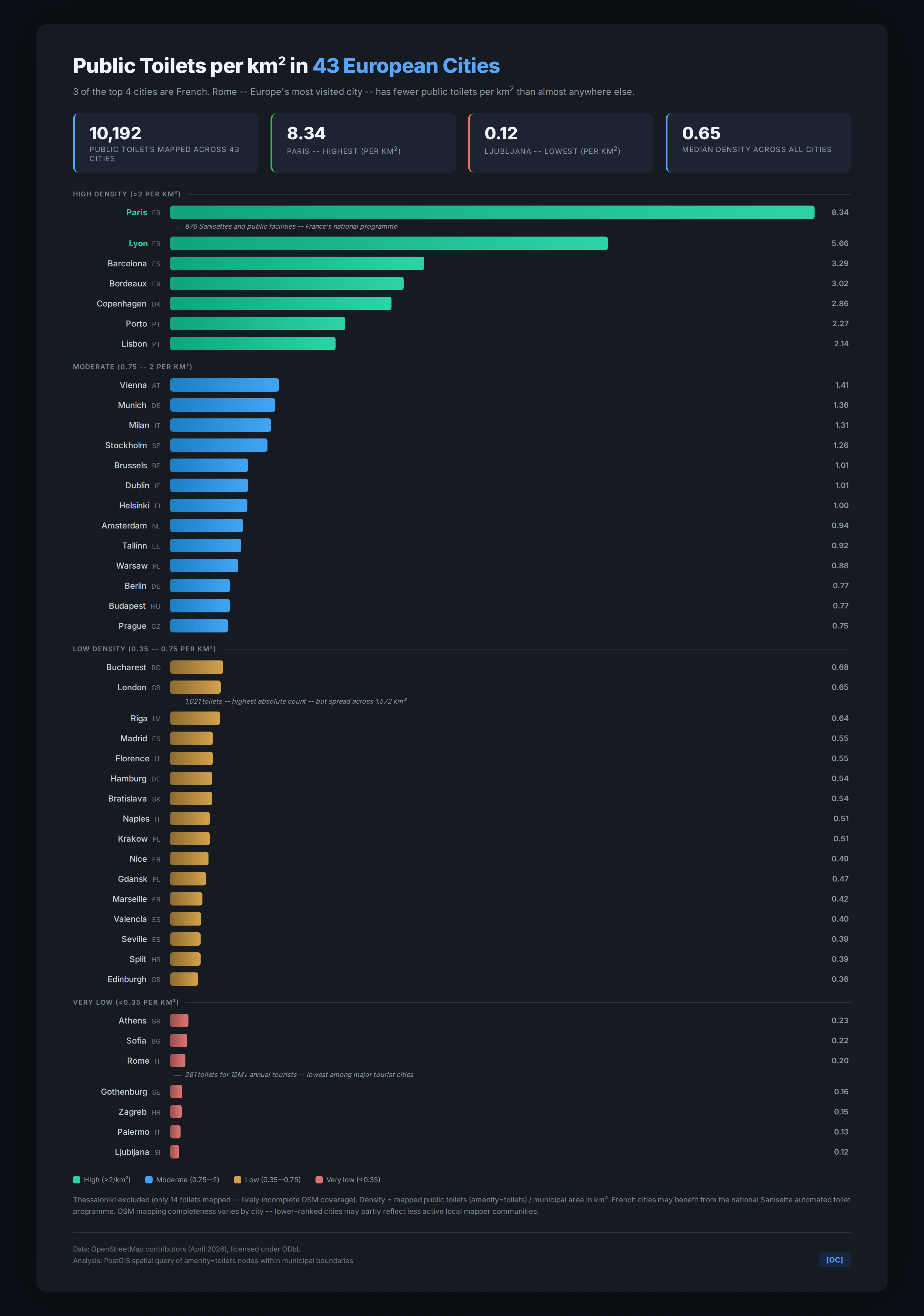
**Methodology:** Counted all mapped public toilet nodes (amenity=toilets) within the administrative boundary of each city. Density = toilet count / municipal area in km². Thessaloniki excluded due to very low mapping coverage (14 toilets).
**Notes:** OSM mapping completeness varies by city — lower-ranked cities may partly reflect less active mapper communities rather than fewer actual toilets. French cities benefit from the national Sanisette automated toilet programme (Paris alone has 750+ units).
holytriplem on
Those Paris public toilets are some of the grossest in the developed world though.
I’m looking at you in particular, *Bercy Bus Station*
swingyafatbastard on
I’m assuming you’re counting the Seine for Paris?
anortef on
What counts as public toilet? because I have lived my whole life in Barcelona and never seen one.
captainhalfwheeler on
Paris toilets are completely unusable.
loggywd on
When you say public toilet, do you mean dedicated toilets owned and run by the government or do they include business toilet publicly accessible too. Because many cities have bylaws to make businesses open their toilets to the public.
hughperman on
As far as I can see from https://mapscaping.com/public-toilet-finder/ , the Dublin layer isn’t really “public toilets” in the sense of “official toilets”. More like “toilets you can get to without paying in a library, museum, university, train station, food court, large shop, etc”. Which is useful, but the number here gives a false sense of official public amenities, which is more like 1 or 2 in the entire city.
gr7calc on
Plotting against population density, rather than area, would be better.
vilkazz on
Why is Lithuania never considered to be part of Europe?
bhalazs on
Lyon is great, they have those self-cleaning toilets that get fully rinsed (not just the toilet seat but the walls, sink, everything) after each use

10 Comments
**Data source:** OpenStreetMap (amenity=toilets nodes), queried April 2026. Licensed under ODbL.
**Tools:** PostGIS for spatial queries within municipal boundaries, HTML/CSS for visualization.
**Methodology:** Counted all mapped public toilet nodes (amenity=toilets) within the administrative boundary of each city. Density = toilet count / municipal area in km². Thessaloniki excluded due to very low mapping coverage (14 toilets).
**Notes:** OSM mapping completeness varies by city — lower-ranked cities may partly reflect less active mapper communities rather than fewer actual toilets. French cities benefit from the national Sanisette automated toilet programme (Paris alone has 750+ units).
Those Paris public toilets are some of the grossest in the developed world though.
I’m looking at you in particular, *Bercy Bus Station*
I’m assuming you’re counting the Seine for Paris?
What counts as public toilet? because I have lived my whole life in Barcelona and never seen one.
Paris toilets are completely unusable.
When you say public toilet, do you mean dedicated toilets owned and run by the government or do they include business toilet publicly accessible too. Because many cities have bylaws to make businesses open their toilets to the public.
As far as I can see from https://mapscaping.com/public-toilet-finder/ , the Dublin layer isn’t really “public toilets” in the sense of “official toilets”. More like “toilets you can get to without paying in a library, museum, university, train station, food court, large shop, etc”. Which is useful, but the number here gives a false sense of official public amenities, which is more like 1 or 2 in the entire city.
Plotting against population density, rather than area, would be better.
Why is Lithuania never considered to be part of Europe?
Lyon is great, they have those self-cleaning toilets that get fully rinsed (not just the toilet seat but the walls, sink, everything) after each use