
TL;DR don’t trust raw GPS elevation gain on smart watches and GPS-based tracking apps. Post-processing often makes it worse. Smoothing helps but can erase real peaks. A hybrid approach (or just using live tracking) gives the most realistic numbers.
Made with MOSTLY AI. Check out the chart and interrogate the data yourself.
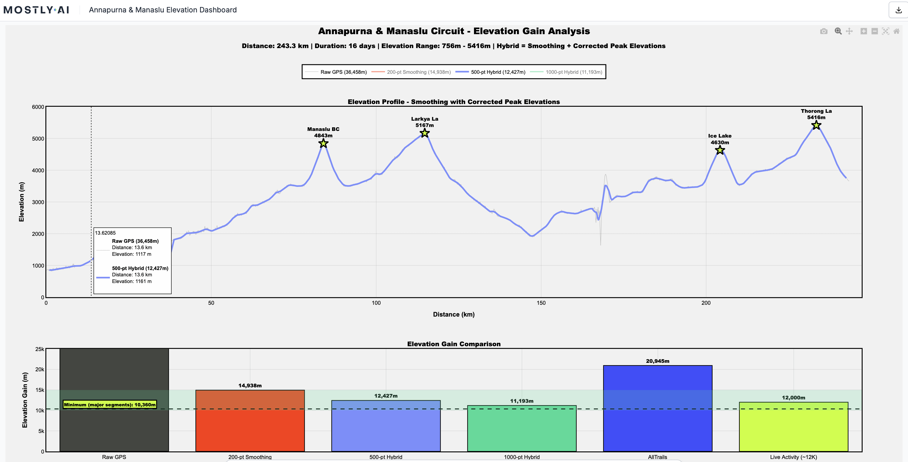
I just finished the Manaslu–Annapurna Circuit in Nepal (243 km, 16 days, two 5,000m+ passes) and found something wild: most GPS apps massively misreport elevation gain. AllTrails showed ~12,000m gain during the trek, but when I exported and combined the GPX files afterward, it suddenly jumped to 20,945m. My own manual calculation of the major climbs gave a minimum of 10,360m. Same app, same data, 75% difference.
So I dug into all 64,982 GPS trackpoints to figure out what was going on. The raw data claimed 36,458m of elevation gain (totally wrong, pure noise). A simple 2m threshold still gave 16,097m. Heavy smoothing (1000-point rolling average) produced 10,685m, which was closer but shaved 50–250m off actual high passes.
The problem is that GPS elevation is insanely noisy: 65.7% of my elevation changes were less than 1 meter, just jitter that artificially stacks up into thousands of meters of fake “gain.”
I built a hybrid smoothing + peak-correction method that preserves real summits while filtering noise, and got 12,427m, which matches the Live Activity tracking almost perfectly.
Pretty wild findings tbh.
by SyllabubNo626
4 Comments
What exactly did you use for recording? What device, which Satellite networks?
It’s not that elevation from GPS is wrong, it just includes noise and you are summing up all that noise. A sort of like the coastline paradox.
I wear a watch with a barometric altimeter while flying small, unpressurized planes. Every time I’ve compared the data after a flight it’s been accurate to within 50ft. While it’s not perfect, if my plane’s altimeter failed during a flight I’m confident it would work well enough to land safely.
What’s the ground truth of the elevation gain on that route? Presumably someone’s measured it with a more accurate device?