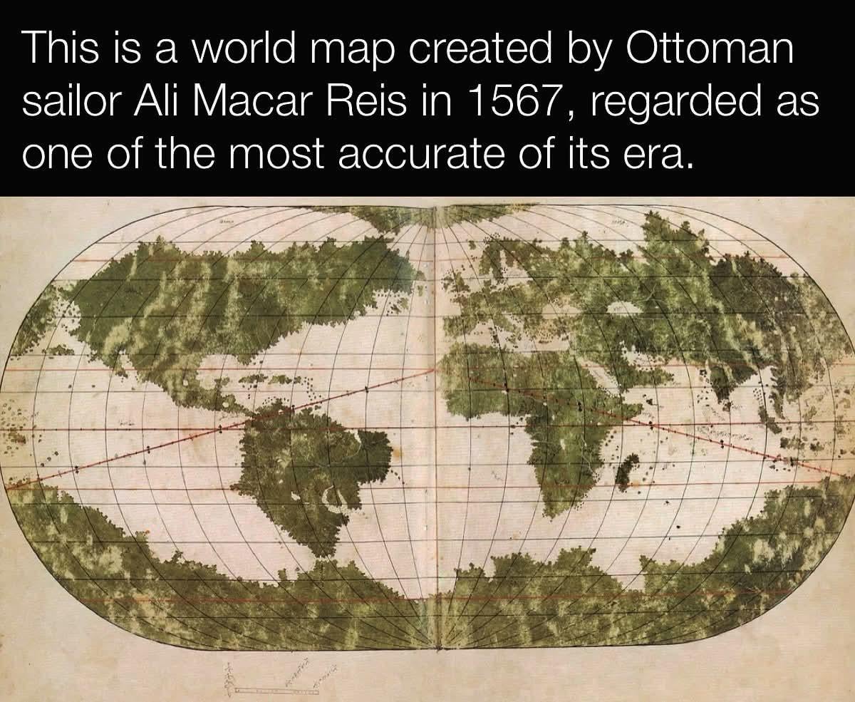
So for anyone interested, here’s what was going on at the time:
* Magellan (Portuguese, sailing for Spain) had circumnavigated the world (1519-1522).
* Spain had conquered Mexico (1519-1521).
* Spain had conquered most of the Inca Empire (1532-1572).
* Spain had [explored the West Coast of the Americas](https://www.nps.gov/cabr/learn/historyculture/juan-rodriguez-cabrillo.htm), at least as far as California, possibly as far as Oregon.
* Spain had just begun conquering the Philippines, and the [Manila galleons](https://en.wikipedia.org/wiki/Manila_galleon), Spanish trading ships that exchanged Peruvian silver for Asian goods, for resale in Europe, had already begun sailing a couple years ago in 1565.
* Ali Macar Reis map (1567).
So “surprisingly accurate” doesn’t mean “esoteric knowledge”, it just means “Ali Macar Reis was well-informed of Spanish imperial and naval advancements”.
Mateorabi on
Has Río de la Plata, but doesn’t have the Chesapeake Bay. And a made-up lake in east Mexico.
ad727272 on
How is it possible for them to be so accurate?
Blueknightuk77 on
Canada was closer to the UK in those days.
Hmmm__whatever on
Dumb-ass should have just googled it!
sjefbuts on
BUT WHERE IS ME ICE WALL?!??!?!?!
EpicGamerJoey on
Why does eastern South America look like the Imperial Isle
Consistent_Bread_V2 on
Interesting postulations like Greenland being connected to North America, and of course Terra Australis
The drake passage area of Antarctica and South America is surprisingly close.
Since greek times until this era they assumed the south had to have equal land to the north, so they assumed Antarctica and Australia were one giant continent with the same humid, temperate, and freezing zones the northern hemisphere had

14 Comments
Yay, no Australia.
Antarctica looks HUGE lol
Not bad. Not bad at all.
Ironically, Turkey seems not to be very accurate.
anyone know what the red diagonal lines are?
So for anyone interested, here’s what was going on at the time:
* Magellan (Portuguese, sailing for Spain) had circumnavigated the world (1519-1522).
* Spain had conquered Mexico (1519-1521).
* Spain had conquered most of the Inca Empire (1532-1572).
* Spain had [explored the West Coast of the Americas](https://www.nps.gov/cabr/learn/historyculture/juan-rodriguez-cabrillo.htm), at least as far as California, possibly as far as Oregon.
* Spain had just begun conquering the Philippines, and the [Manila galleons](https://en.wikipedia.org/wiki/Manila_galleon), Spanish trading ships that exchanged Peruvian silver for Asian goods, for resale in Europe, had already begun sailing a couple years ago in 1565.
* Ali Macar Reis map (1567).
So “surprisingly accurate” doesn’t mean “esoteric knowledge”, it just means “Ali Macar Reis was well-informed of Spanish imperial and naval advancements”.
Has Río de la Plata, but doesn’t have the Chesapeake Bay. And a made-up lake in east Mexico.
How is it possible for them to be so accurate?
Canada was closer to the UK in those days.
Dumb-ass should have just googled it!
BUT WHERE IS ME ICE WALL?!??!?!?!
Why does eastern South America look like the Imperial Isle
Interesting postulations like Greenland being connected to North America, and of course Terra Australis
The drake passage area of Antarctica and South America is surprisingly close.
Since greek times until this era they assumed the south had to have equal land to the north, so they assumed Antarctica and Australia were one giant continent with the same humid, temperate, and freezing zones the northern hemisphere had
Nice something actually unique and interesting!